Lathkill Dale is one of the prettiest of the Derbyshire Dales and lies about 3 miles from Bakewell. There is a pay and display car park at Over Haddon from where a steep road descends into the dale, or various parking areas at Monyash which is situated at the top end of Lathkill Dale. Alternatively, limited roadside parking is available at medieval Conksbury Bridge on the road from Bakewell to Newhaven or at Alport at the bottom end of Lathkill Dale
The true source of the river Lathkill is said to be around the Knotlow area between Flagg and Monyash, but the river does not appear above ground until it reaches the amazing Lathkill Head Cave about half a mile down the valley from Monyash
The river Lathkill is a very secretive and shy watercourse as it disappears and hides in places, allowing sections of the river bed to become dried out in summer or during drought conditions. This is because of the abundance of old lead mining shafts and workings which draw and entice the water underground. However, after heavy rain or during winter months there are areas where the river is prone to flooding!

A particularly attractive area of Lathkill Dale is the section below Over Haddon where crystal clear water bubbles up from swallet holes to flow into deep pools known locally as The Blue Waters. The colour could be attributed to the purity and clarity of the water but also to the rich mineral content as the water flowed through limestone bedrock.
There is a succession of some 12 weirs beyond The Blue Waters which were constructed to encourage trout to breed and as fishing pools in the 19th century (fishing rights on the river are strictly private). Here the river Lathkill becomes tranquil and serene, its calm surface being perfect for ducks, moorhen and coot.
To describe Lathkill Dale in detail, it might be best to start close to its source and then work our way downstream.
Walking down Lathkill Dale from Monyash you will come to the remains of Ricklow Quarry where there are huge mounds of limestone slabs. The crinoidal limestone found at Ricklow was well polished to look like marble and became extremely popular with Victorians.
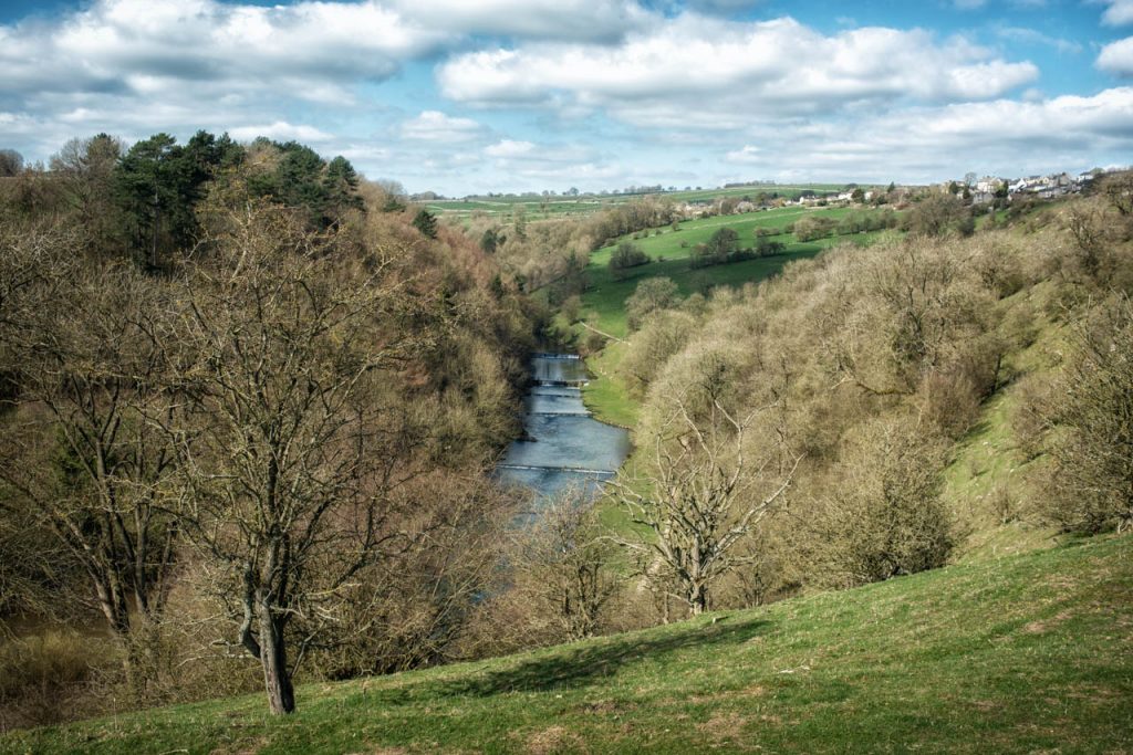
You will now enter the nature reserve of national significance which contains several rare species of plants including the rare Jacobs Ladder that can be found growing in one isolated location in Lathkill Dale. There are also a rich variety of insects, trees and animal life and several Sites of Special Scientific Interest (SSSI’s), whilst some birds of prey including buzzards, kestrels and even goshawks can sometimes be seen soaring above. Certain areas of Lathkill Dale have now been designated as Access Land as shown on the Ordnance Survey maps.

Natural England maintain and manage parts of Lathkill Dale, helping to preserve and conserve the wildlife, flora and fauna, whilst making Lathkill Dale accessible to the many tourists who visit each year.
After walking down the rocky path of exposed stone with steep grassy banks and crags on either side you will come to Lathkill Head Cave where the River Lathkill makes its first appearance, although in summer months and dry spells there is often nothing flowing from this huge mouth in the side of the dale.
On the left is Parsons Tor, a corner of headland with a limestone buttress named after Robert Lomas the then vicar of Monyash who fell to his death from his horse in 1776 when returning late one night from Bakewell in a drunken state.
As Lathkill Dale continues it gains depth and character. The lower sides are slitherbanks or screes created by the constant erosion of water thousands of years ago, frost and weathering, whilst on the ridge tops are some fascinating rock formations where the limestone has been shaped into strange forms.
You will come to a little wooden footbridge which has replaced an old stone clapper bridge. This gives access to Cales Dale with paths leading west to One Ash Grange or east to Calling Low. It is reputed that long ago the stone pillars holding up the former clapper bridge were supported by metal wheels taken from the canons of Cromwell’s army when he came through the valley with his roundhead battalions?

There now follows a very dramatic section of Lathkill Dale where the river changes from a little trickle to a more substantial flow, having been swelled by numerous natural springs which drain into it from surrounding hillsides. Water vole can sometimes be seen nibbling away in the reeds whilst wagtail and dipper bob, dip and curtsey on exposed rocks.
Just before reaching a wide stretch of Lathkill Dale you will come to the tufa cascade where the river cascades down over moss and fern covered rocks into a sheltered pool that makes the most idyllic picnic spot.
We now reach the remains of Carters Mill where water is held back in the old mill pond before tumbling down the many stepped weir. There is not much evidence of the old corn mill other than a couple of millstones embedded in the ground, the old iron water wheel having been removed for scrap during World War II.
From Carters Mill the river Lathkill flows through Palmerston Wood where a concessionary riverside path leads through the ash, alder, willow, beech, sycamore and birch. (During the shooting season the woods are closed to visitors on Wednesdays).

As you wander through the tranquil dale, surrounded by nature at its most glorious it is hard to imagine that Lathkill Dale was a totally different scene a couple of centuries ago, when it was a hive of industry with several lead mines, countless shafts, processing plants, engine houses and many miners all culminating in noise, dust, grime and grim conditions. Nature has healed the scars and taken over the land again, making Lathkill Dale an area of outstanding beauty once again, but as you walk along you can see lots of remains of the lead mines in the form of dips, hollows, capped shafts, adits, soughs, crumbled pillars and weathered stone walls, all blending in and adding character to Lathkill Dale
A new landmark to Lathkill Dale is the wooden bridge constructed in 2004 which appears a little like something from a Chinese water garden. This provides access to the ruins of Bateman’s House and was constructed by Natural England with a generous donation from the Heritage Lottery fund. Natural England stabilized the old ruins and made the site accessible to visitors. The house was originally built in the 1840’s for Thomas Bateman who was agent of the Lathkill Mine. Incredibly, it was constructed directly over a very deep mineshaft which until the recent renovation work made it an extremely dangerous site. However, now it is possible to descend a short metal ladder and use a hand-operated generator to see down into the hidden shaft.
A fascinating recent discovery close to Bateman’s House in Lathkill Dale was an engraved sandstone boundary marker which would have been placed on the border of land belonging to the Duke of Devonshire (DD) and Melbourne Estate (M).
A section of river from Bateman’s House to about ¾-mile downstream is particularly prone to drying up in dry or drought conditions. This has an impact on fish in the river, and although it looks a perfect environment for trout, it is very rare to see fish swimming here.
Downstream of Bateman’s House there are a series of stone pillars crossing the dale. These were once much taller and carried an aqueduct where water which was taken from the main river close to Carters Mill and used to operate a giant waterwheel at Mandale Mine. Hidden in the trees a short distance away is the remains of Mandale Mine which include the bob wall of the engine house and a gated mine entrance. There is an interesting information plaque which illustrates what Lathkill Dale was like a couple of hundred years ago.

A lovely flat path runs beside the old sough and river Lathkill to the fishing lodge and 15th century corn mill which is located at the bottom of a steep lane to Over Haddon. Here there is an old clapper bridge beside the river whose banks are coated with huge butterbur leaves in late spring and summer.
Shortly after the lodge the path follows uneven ground beside The Blue Waters mentioned earlier, where miniature limestone cliffs draped with hanging ferns cast a fabulous reflection in the crystal clear water.
It is interesting to note that Charles Cotton, the famous doyen of fishermen, wrote of the ‘Lathkin’, “it is by many degrees the purest and most transparent stream that I every yet saw, either at home or abroad, and breeds it is said the reddest and the best trout in England”.
By the side of a wooden gate are the derelict remains of an old pumping station which fed troughs in the village of Over Haddon high on the hillside above until mains water was installed.
In 1854 the bank on your left took on a ‘Klondike’ appearance. It was claimed that gold had been found in a bed of volcanic toadstone, resulting in the £1 shares in the mine to escalate practically overnight to £30 each. After much publicity and excitement the gold was analysed as iron pyrites or ‘fools gold’ and within a short while the mine was closed, thus ending the Lathkill Gold Rush!
After about ¼-mile of fabulous riverside path you will emerge at medieval Conksbury Bridge where at first the river Lathkill appears to flow beneath a long solid wall until you observe the tiny low-down arches. This old bridge carried the Newhaven to Grindleford turnpike and was also used as a sheepwash bridge until after World War II. The settlement of Conksbury stood on the banks to the south but was abandoned centuries ago.

To continue on the riverside path you have to walk up the road for a couple of hundred yards or so and then go over a stile on the left. Just a little further up the road there once stood a tollhouse opposite Conksbury Farm. In White’s directory of 1857 it names the tollbar keeper as being Edward Bowman whose family owned the farm for several generations.
The Lathkill is now progressing slowly through a particularly scenic stretch of Lathkill Dale, passing Raper Lodge that is a former gamekeepers house which was the setting for the parsonage in the film ‘Virgin and the Gypsy’. Across the river is a very quaint little fishing housed owned by the Haddon Estates. It featured a few years ago in a series of programmes about Belvoir Castle and Haddon Hall which showed the then Duke of Rutland fishing at this very spot. There is also the most wonderful arched packhorse bridge. Coalpit Bridge as it is known was where long trains of packhorses crossed the river Lathkill laden with coal from the mines around Chesterfield.
After increasing in size to a fully fledged river and flowing beside meadows of rich pasture, our river Lathkill reaches Alport, a picture postcard estate village of the Haddon Estate with chocolate box pretty cottages. Behind the back garden of ancient Monks Hall our little river ends its journey when it joins forces with the Bradford. However, the combined water will continue to flow through yet more wonderful Derbyshire landscapes before uniting with the Wye and Derwent and on through Derby to the Trent. It may not have been the longest river in England, but there are many that say the river Lathkill is by far the prettiest and purest.